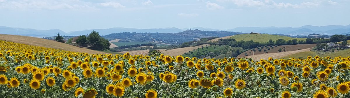
We could not have hoped for better weather for our trip. It had been hot and sunny for a solid fortnight or so, but a persistent haziness had dulled the sky, blurred the horizon and kept the peaks of Sibillini Mountains all but hidden within a veil of light gauze. As we set off down the hill early on Sunday morning, however, the mountains stood out on the western horizon with such clarity and grandeur against the brilliant blue sky that we could have been looking at them through a magnifying glass.
We were heading to the tiny hamlet of Foce di Montemonaco, located 945m up in the far south-eastern corner of the Parco Nazionale dei Monti Sibillini. This is where Mr Blue-Shirt and I had arranged to meet up with Richard, a former teaching colleague of mine, with whom I had discovered a shared interest in hiking some months earlier, his wife Jane and one of his two teenage daughters. Then from here we would set out together one of the best-known and most spectacular hikes in the park, the 10km trail up to the Lago di Pilato that lies at 1949m.
According to the most popular version of the legend that gave lake its name, it is the final resting place of the body of Pontius Pilate. He is said to have been sentenced to death in Rome by Emperor Tiberius (or possibly Caligula) for having ordered the crucifixion of Christ. Whichever emperor it was allegedly agreed to Pilate’s final request for his body to be placed on a chariot pulled by buffaloes which would be left free to roam as they pleased, and they ended up on the shores of the lake where they threw themselves in along with the chariot and Pilate’s body.
After a quick coffee and a pastry in the garden of the village’s only café/restaurant/hostel, the five of us hauled on our boots, swung our backpacks onto our shoulders and set off onto the trail. It was only about 9.30am, but it was already getting hot, despite the altitude. The first section of our route took us due south along the Piano del Gardosa and we were glad of the dappled shade offered by the trees that edged the broad, rocky path as it meandered steadily uphill through lush mountain pasture sprinkled with red, yellow, pink, purple and white flowers. Heavily wooded hills rose up on each side of the narrow, glacial valley that was filled with golden sunlight and around which a chorus of birdsong swirled on the light breeze. We walked and talked at brisk pace, catching up on each other’s news and respective holiday plans while stopping only briefly to identify a flower, a bird or a bug and completed the first four kilometres in under an hour.
As we approached the end of the valley, however, a phalanx of imposing crags reared up in front of us, the beech trees that clung to their near-vertical flanks apparently defying gravity. Within a few minutes we had plunged into the cool green shade of the forest, but any relief it offered was short-lived. Almost instantly the broad, open path turned into a steep narrow track that wound back and forth up the mountainside, weaving among trees and ferns, round tangles of gnarled tree roots, and over mossy slabs of rock. In minutes our legs and lungs were pleading for mercy, but the ascent was unrelenting and at times it became more climb than walk. On the map, we had noticed the closeness of the contour lines on this section of the route, but hadn’t fully appreciated just how precipitous it would become. From time to time we paused to catch our breath, swig some water or make way for those serious early-birds who were already on their way back down. With every stop we craned upwards in the hope of glimpsing the summit, or even a fragment of sky, but all we could see was yet more of this never-ending forested wall so on and up we laboured.
A good hour but barely two kilometres later, according to Richard’s fitbit, the slope at last began to ease a little, the forest gradually became less dense, and finally we emerged into brilliant sunshine spilling across a vast expanse of upland pasture ringed with towering peaks. But our relief at having completed the most demanding part of the route was tempered by the knowledge that we still had several hundred metres more to climb over the remaining four kilometres of the route. After a few minutes’ rest, however, and a good drink of water, we were good to go again. And if anything was going to take our minds off the relentlessness of the continued ascent it was the majesty of the dramatic landscape. To our left and right limestone peaks soared up into the vivid blue sky, their upper slopes still flecked with occasional patches of snow while drifts of jagged scree gathered on their lower slopes. And as we slowly picked our way among the chunks of rock that dotted the sparse covering of grass across the bottom of the valley, flocks of chough circled high above us, their screeching calls echoing off the bare rockfaces. Onwards and upwards we slogged, the thinning air now filling our legs with lead and slowing our progress. But as the valley steepened further, the grass became sparser and the summits of the two highest peaks in the Sibillini at last came into view- Monte Vettore (2476m) and Cima del Redentore (2069m) – we knew that we were nearly there. For it is these two mighty peaks that stand guard over the Lago di Pilato located at the bottom of the deep crater between them.
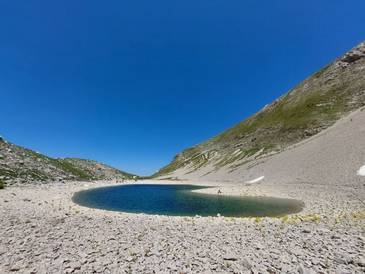
Then suddenly, as we crested a small hillock, the tiny lake finally appeared before us: a sapphire pool of gin-clear water, shimmering beneath the midday sun, its twin guardians, along with the craggy bulk of the sheer-faced Pizzo del Diavolo, towering menacingly over it. We had made it! Three hours, ten kilometres and a climb of a thousand metres. No wonder we were knackered. All five of us dragged our backpacks off, flopped down onto the rough, springy grass, grateful for the cooling breeze that tugged at our sweat-dampened T-shirts. Having recovered our breath, we took a few moments just to absorb the awe-inspiring immensity of our surroundings, much like everyone else who had made the trek and now lay stretched out on the area of flattish ground above the lake. Whether munching their sandwiches, exploring the lakeside, or preparing to set off back down the trail, however, everyone remained strangely quiet, almost reverential in the presence of such magnificence.
Our hunger eventually overrode our awe, though, and food briefly became our priority. But once we had wolfed down our picnics, each of us wandered off in different directions to explore the shoreline and take a closer look at the limpid waters of what actually now consists of two almost identical pools, the further one initially hidden from view by the broad ridge of scree that separates them. Until reduced snowfall caused the water level to drop, however, they were connected by a narrow strip of water that from above made the lake look like a pair of spectacles, hence its nickname ‘the glasses lake’. The fragility of the two pools gives them an almost magical air that is reinforced by environmental regulations which mean it is now strictly forbidden to as much as place a hand in their pure, crystalline waters.
After a good hour’s exploring and resting, we eventually pulled our rucksacks on again and set off, slightly apprehensively, back down to Foce. For while the return trip might have been downhill all the way, we knew that the 1000-metre descent was unlikely to be any easier or faster than the way up. The steepness of the route meant that every couple of hundred metres or so one or other of us lost our footing on the loose stones that made up the narrow winding track, and although walking on the grass was less slippery, it was no more even, so stumbles were almost as frequent. The really steep part made the constant jarring of our weary knees even worse, and at some points, the only safe and comfortable way down was, as Jane delicately put it, to ‘lower one’s centre of gravity’ – ie shuffle down on your backside. With fatigue starting to tell, the relief at reaching the bottom of this section was just as great as it had been at the top, and although the final four kilometres that followed were much less steep and slippery, they felt twice as long as when we set out and our pace slowed to a plod. At last, though, the terracotta rooftops of Foce di Montemonaco re-appeared among the trees, and we could almost taste the ice-cold beer we had been promising ourselves for at least the previous hour. So with this thought spurring on, we picked up our pace and positively strode the last the last few hundred metres back into the village. And at shortly after 5.00pm, we finally plonked ourselves down on the same bench where we’d eaten breakfast just over seven hours earlier and raised our hard-earned, ice-cold beers to toast our 2000-metre, 20-kilometre achievement.
